Vision and Motivation
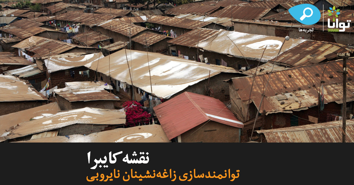
The informal settlement of Kibera is not only the largest slum in Nairobi, it is said to be the largest slum in Africa. With a population estimated at approximately 230,000[1], one might assume that Kibera’s needs would be a top priority for the Kenyan government. Kiberans, who have a life expectancy of just 30 years, suffer from a severe lack of clean, running water and toilets; hunger is so rampant that 66 percent of girls in the slum routinely trade sex for food by the age of 16.[2] However, Kibera has been largely ignored by those outside its vicinity. In fact, until recently, Kibera was very literally invisible, appearing only as a large blank space or an uninhabited forest on virtually all maps.[3]
Paradoxically, while remaining invisible on maps, Kibera was saturated with well-meaning NGOs, faith-based groups, and foreign researchers. Although these international groups generated a large body of knowledge on Kibera, their information failed to create any meaningful change. There was a vast disconnect preventing any dialogue between the residents who understood Kibera’s problems and those with the means to help.[4]
In November 2009, Mikel Maron and Erica Hagen, two people who had never been to Kibera, or Kenya for that matter, began the Map Kibera project to empower the citizens of Kibera to record “data [and] news reports, [to] map information about themselves and their community, and to use that information for action.”[5] As Hagen put it, “Map Kibera was founded on the premise that the digital age makes it possible to bypass traditional gatekeepers to information and data…thereby allowing citizens to create and use new information systems.”[6] The Map Kibera project trained a corps of citizens in GPS technology, which they then used to map their community and its problems. As one Kiberan man says, “Now that such a map is there, it can hold officials accountable so you can tell them look, here is a population of 200,000 people with no facilities. What are you doing about it?”[7]
Goals and Objectives
The Map Kibera project makes Kibera’s needs visible. Knowing that information on Kibera would be most impactful, relevant, and accurate coming from the people themselves, Map Kibera took an extremely localized approach; they trained citizens of Kibera to use GPS technology to collect data and plot problems, then use the collected information to influence policy and development by advocating for their needs.[8] 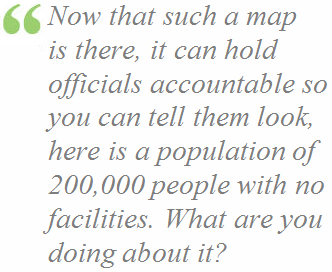
Initially, the project focused solely on training young Kiberans to create a map. Kibera had its own services, but many residents had no idea where they were located. However, with mapping technology, the people of Kibera could record and publicize locations for markets, schools, religious centers, hospitals, clinics and pharmacies, bathrooms, and water points.[9] Within three weeks, in organic fashion, the project had successfully created an incredibly dense and publicly accessible map.[10]
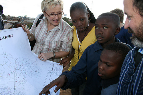
After experiencing life in Kibera, however, project co-founders Maron and Hagen realized that a map was not enough; the Map Kibera project had to delve deeper. Maron says, “It started off like ‘let’s make a map,’ but at this point we’re like, ‘let’s help build a community.’”[11] The project shifted focus to create a variety of services which would leave a lasting impact on Kibera’s daily life. For example, another map was created specifically to increase safety for women and girls. Locals recorded which areas were dangerous, which were safe, where there were no streetlights at night, and so forth. Areas of reported rape were marked as “black spots.” One young mapping participant describes the project’s impact: “If we find a girl who has been raped, nowadays they don’t keep quiet. They talk.”[12] Six months after the map’s creation, a new police post was erected on a former “black spot.” Another mapping participant declares, “Through this we gained not only local knowledge, but also excitement…because we found that the community could respond positively. To me, this is a lifetime achievement.”[13]

In its next phase, the project sought to further engage the community, especially youth, by empowering residents with citizen journalism skills, “to allow Kibera residents to speak for themselves on current events and issues, and to create a digital community around local information.”[14] They founded The Voice of Kibera, a website for mapping local news about anything, ranging from power outages to free showings of the World Cup, and the Kibera News Network, which taught Kiberan youth to film reports on Kibera and upload the videos online. As Fredrick Barry, a Kibera local and Voice of Kibera employee, says, “More often people associate Kibera [with] violence and all sorts of negativity, giving the world at large a negative mentality toward Kibera. [I’m thankful for] the Voice of Kibera because it gives out the true image of Kibera, highlighting [the community’s] grievances as well as their views in all areas of life. I feel great when I give out the truth regarding Kibera.”[15] Kiberans could even post comments on the effectiveness of local NGOs so that citizens could gain access to the most effective services.[16]In the area of health, mappers could track important details such as the number of trained nurses in a hospital, and record videos of clinics and toilets. One mapper says, “Whatever we’ve done in Kibera shows that youth can do anything. We can come together and make something that the whole world can really see and appreciate our work. So let us not sit back and wait for other people to do [things] for us.”[17]
Leadership

Map Kibera’s founders, Mikel Maron and Erica Hagen, come from different backgrounds. Maron is a specialist in digital mapping known for his work with OpenStreetMap, a free, editable online worldwide map. After working on mapping projects in Palestine and India, he says he “heard of a crazy, off-hand suggestion to map this slum called Kibera in Kenya. It sounded like an incredible challenge and, potentially, something really beneficial.”[18] Hagen, on the other hand, had learned of grassroots mapping only very shortly before the project’s launch. She joined Map Kibera because of her enthusiasm about changing the nature of international development by empowering marginalized communities to advocate for themselves. Neither of the two had ever been to Kibera, or even Kenya, before, and they originally anticipated spending less than two months in Kenya in late 2009 for the project.[19]
At first, the main challenge the project faced, ironically, was from the very group Map Kibera was designed to help: the citizens of Kibera. The project encountered much skepticism from the local populace, wary from previous interactions with corrupt officials and ineffective NGOs. Kiberans questioned why the project was mapping Kibera – were they trying to gather information on behalf of the government? Would the map data be used to evict residents or tear down their homes?[20] The project responded by holding an open discussion with Kiberans about the project’s goals, and more importantly, by empowering the citizens of Kibera to play an active role in the mapping process. The teams of mappers were almost entirely made up of Kiberans, giving them a sense of ownership in the project. As one mapper put it, “When I saw the map for the first time, I was proud. This has not been done by other people. It has been done by me.”[21]
After the initial mapping phase, the project realized that simply creating a map of Kibera was merely a foundation for creating a resource that would offer practical use to Kiberans; Maron and Hagen returned to Kenya for nine months in 2010 in order to develop a comprehensive community engagement model of citizen journalism and advocacy. From that point on, the project co-founders have left the project largely in local hands; as Hagen says, “We believe that if we step back from the day-to-day operations of Map Kibera, the organization will eventually be the stronger for it.”[22]
Civic Environment
 Kibera’s lack of widespread Internet access and technology knowledge has left it increasingly isolated from the rest of the world. This digital divide meant that just as Kibera didn’t receive news from the outside, nor did the outside receive news from Kibera. On the rare occasion that journalists did enter Kibera, it was only to attempt to perform a sort of “muckraking,” spotlighting violence rather than delving into the residents’ thoughts or opinions.[23] Thus, it proved difficult for outsiders to understand where Kibera most needed help and how help could be provided. Moreover, at the time Map Kibera was launched, Kiberans who did use Internet cafes were accustomed to using the Internet simply for chatting with friends and looking up information, rather than as a “participatory tool for change.”[24]
Perhaps more importantly, Kiberans largely lacked a sense of civic duty. The Map Kibera team entered Kibera hoping to find participants motivated by the desire to improve their city. However, they found instead “a community so influenced economically by years of ‘interventions’ by various international development organizations that a full shadow economy had developed.”[25] It was common practice for NGOs to pay Kiberans to take part in their programs.[26] This expectation of payment made it difficult for Map Kibera to attract true civic participation. Accordingly, the project made it clear in advance that payment would not be offered for participation, thereby attracting fewer mappers, but ones who were genuinely motivated to participate.[27]
The project realized, “We had to make these activities really worth their while, and create a working relationship based on trust that could lead to improvements” in Kibera.[28] So Map Kibera offered technical training in mapping, filming, and editing technology – training that would open up new, long-term employment opportunities for participants beyond their work with Map Kibera. As Hagen said, “We wanted the local youth to begin to network with Nairobi’s technology community and start to bridge the digital divide: we wanted them to see career possibilities in [the technology field].”[29] The opportunity to build skills and improve their prospects for employment gave Kiberans an incentive to join the project; as one journalism student says, “My knowledge didn’t come from books and lecturers, it came from interest, determination and persistence to know about filmmaking.”[30]
Message and Audience
 Map Kibera has striven to empower all Kiberans with the possibility to record, distribute, and access information to take charge of their own development. Because many Kiberans do not have regular Internet access, the project printed paper maps to be distributed throughout schools, churches, clinics, and other public places.[31] They also presented maps at small community meetings so participants could make corrections and add their opinions. Meanwhile, Voice of Kibera developed a mobile version of the site so that Kiberans could submit and read news reports by phone, along with an SMS alert system residents could use; the website also publicized its existence through outreach via traditional media.[32] This way, all Kiberans had access to the project.
Map Kibera’s work soon became well known, particularly as organizational partnerships led to interviews on local radio stations and features on national news networks. The project was featured in two separate documentaries about Kibera. After some initial skepticism, Kiberans took ownership of the Map Kibera project, seeing how it could help a range of people, from citizens looking for the best medical facilities or trying to learn where they could vote, to NGOs aiming for more effective service delivery. As one Kiberan says, “Map Kibera has really helped my people know what we have in our community and how to make use of and improve what is available. We were able to collect information on all the schools, toilets, shops, kiosks, health centers and street lights, producing a complete and detailed map.”[33]
Outreach
 The Map Kibera project has worked with partner organizations since its launch. Indeed, as Hagen says, “Local organizations were keen to be represented, and when we made a presentation to local NGOs, almost everyone was eager to learn how they could use the map to highlight their activities or how they could use these tools in other parts of Nairobi.”[34] Initially, the project partnered with three local organizations already operating within Kibera. One helped set up the system residents used to text news to the website, while the others used their local connections to recruit and train youth mappers and videographers. The project reached international recognition as it partnered with UNICEF in February 2010 to map topics relevant to girls’ security.
Map Kibera has served as a model for other global initiatives. December 2010 saw the start of “Map Kibera Goes to Mathare,” another Nairobi slum.[35] Across the ocean, a crisis map modeled after Kibera’s was started in Haiti after the 2010 earthquake.[36] Initially, that project mapped remaining roads and infrastructure after the disaster; however, it went on to train Haitians to map their transportation, education, health, and water and sanitation facilities.
The Map Kibera Project has far surpassed its founders’ goals, having a tangible effect on the lives of Kiberans today. It has served such practical purposes as: labeling and monitoring polling places for the March 2013 Kenyan election, publicizing locations of health facilities, schools, and other services, warning citizens about natural disasters, and raising NGOs’ awareness of local needs. Kibera, no longer invisible, now has a community of engaged, skilled citizens, trained to use technology to advocate for change. One Kibera mapper describes the project’s impact on her life: “The training and the whole process of mapping have changed me…I used to be very shy and afraid of speaking in public, but now I feel much more confident and well informed… I believe that if by the grace of God I am able to fulfill my dreams, I will not leave Kibera but will stay and make it a better place to live.”[37]
Learn More
News and Analysis
Hagen, Erika. “Putting Nairobi’s Slums on the Map.” The World Bank Institute. 1 Jan, 2009.
Ngito, Kepha. “The power of self-representation: How slum communities prevented violence in Kenya elections.” Eufrika.org. 16 May, 2013.
“Kenya: Freedom in the World 2013.” Freedom House. Jan. 2013.
“Map Kibera.” Map Kibera, OpenStreetMap Contributors.
“Voice of Kibera.” Map Kibera.
Books
Davis, Mike. Planet of the Slums. New York: Verso Books, 2006.
Neuwirth, Robert. Shadow Cities: A Billion Squatters, a New Urban World. Routlegde, 2006.
Multimedia
“Audio slideshow: On the map.” BBC News: Technology. 17 Jan, 2007.
Good Fortune. Dir. Landon Van Soest. Transient Pictures, 2010.
Kibera News Network. Youtube.
“Map Kibera: Blogging the First Open Map of Kibera.”
“Patrick Meier at TedX – Changing the World…One Map at a Time.” YouTube. 14 May 2012.
Footnotes
[1] Maron, Mikel. “Kibera’s Census: Population, Politics, Precision.” Map Kibera Blog. 5 Sept. 2010.
[3] WPSU. “Geospatial Revolution: Mapping Power to the People.” 2 May 2011.
[5] Map Kibera. “Plan Management Meeting.” 28 July 2010.
[9] Cao, Sandy. “Mapping Kibera’s Slums.” Center for Community Mapping.
[11] Heacock, Rebekah. “Map Kibera.” Technology for Transparency Network. 18 Feb. 2010.
[12] Map Kibera. “Map Kibera Girls Security.” 14 June 2010.
[13] Awino, Regynnah and Map Kibera. “Map Kibera and Regynnah’s Empowerment.” UNICEF. 2011.
[15] Lundine, Jamie. “Meet the Voice of Kibera Editorial Board!” Map Kibera Blog. 18 July 2010.
[17] Raftree, Linda. “Youth mappers: from Kibera to Kinango.” Wait…What? Blog. 30 July 2010.
[18] Parfitt, Ben. “Putting Yourself on the Map.” Geographical Magazine. April 2012.
[23] Ngito, Kepha. “How slum communities came together to help prevent election violence.” Map Kibera Blog. 21 March 2013.
[25] Hagen, Erica. “Livelihoods and the Kibera Economy, Part 1.” Map Kibera Blog. 29 Jan. 2011.
[30] Lundine, Jamie. “Digital mapping and governance: the stories behind the maps.” Map Kibera Blog. 28 Jan. 2012.
[35] Map Kibera Goes to Mathare
[36] Hesse, Monica. “Crisis mapping brings online tool to Haitian disaster relief effort.” The Washington Post. 16 Jan. 2010.